
BTS Updates Datasets to National Transportation Atlas DatabaseFriday, October 27, 2023 The U.S. Department of Transportation's (USDOT) Bureau of Transportation Statistics (BTS) today released its fall 2023 update to the National Transportation Atlas Database (NTAD), a set of nationwide geographic databases of transportation facilities, networks, and associated infrastructure. With this data release, one (1) new layer has been added to the NTAD, a layer showing the locations of the Spaceports within the U.S. The updated layers in this release include:
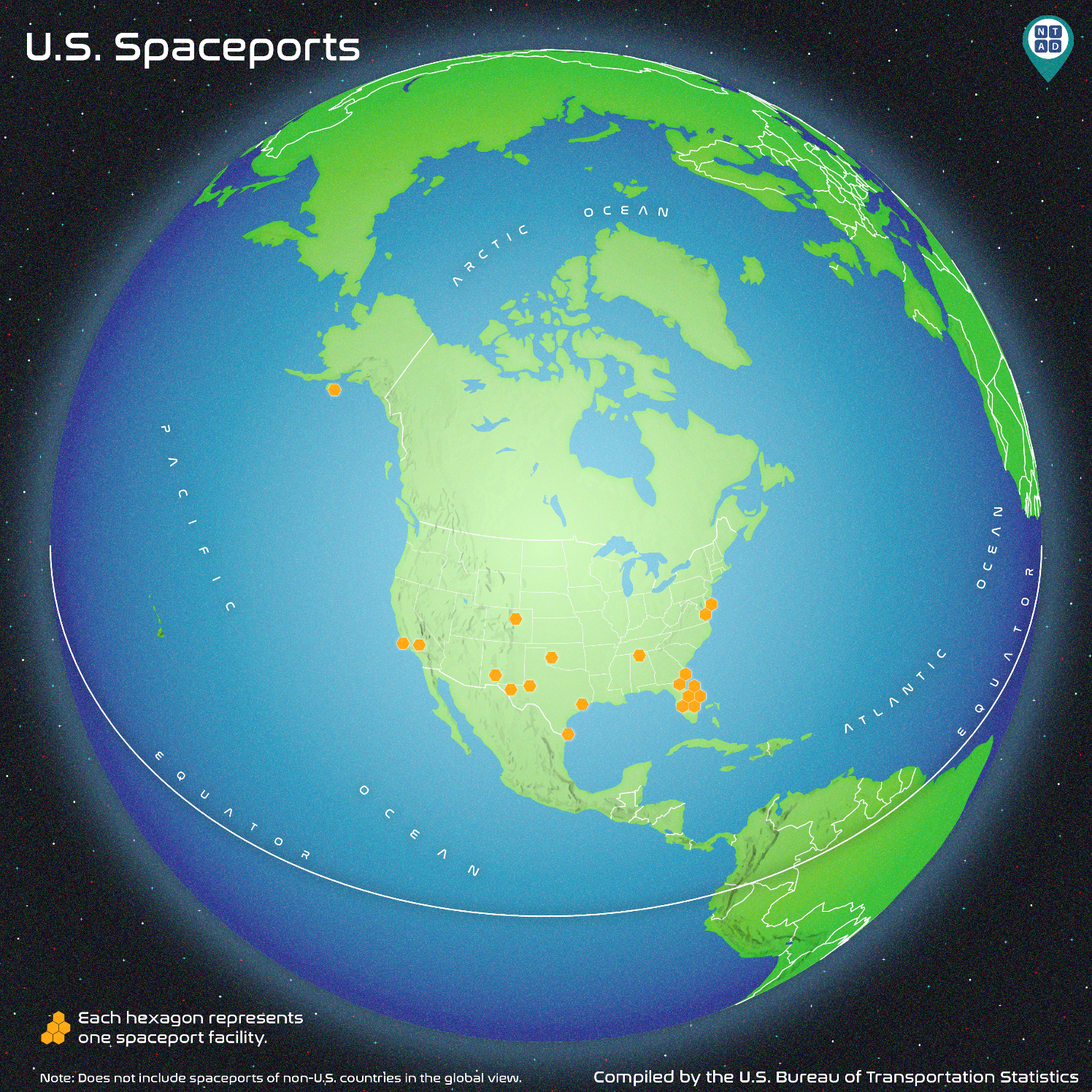
The map below depicts the various spaceports in the United States. U.S. Spaceports span the nation with facilities from the Atlantic coast of Florida to the Gulf of Alaska. Spaceports are predominately located in the southern U.S. to take advantage of the earth's substantial rotational speed at the equator, this minimizes the quantity of propellant used to exit the atmosphere and allows for larger spacecrafts. Florida has the most spaceports clustered around the Cape Canaveral space complex at six, followed by Texas with four, California and Virginia with two, and Alabama, Alaska, Colorado, Georgia, Oklahoma, and New Mexico with one.
About the National Transportation Atlas DatabaseNTAD data is available for download in comma separated values (CSV), Keyhole Markup Language (KML), and shapefile formats through the BTS Geospatial Data Catalog. Additionally, Open Geospatial Consortium (OGC) standard Web Feature Services (WFS) and Web Mapping Services (WMS) are available for all NTAD datasets, here and here. Also available are optimized services for fast rendering of full NTAD datasets and vector tile services for 13 of the largest NTAD datasets. These faster services are designated in NTAD by service names ending in "DS" for each layer and "VT" for the vector tiles services. BTS now uses a dynamic NTAD publication cycle, with updated data released throughout the year as they become available from their respective government agencies. Follow BTS on Twitter, LinkedIn, and Instagram or subscribe to email updates for announcements of additional dataset releases throughout the year. ContactsMedia: BTSNews@dot.gov. Technical: Dominic Menegus: 202-306-1587 or ntad@dot.gov. [1] National Aeronautics and Space Administration, Solar System Exploration. Basics of Space Flight. Washington, DC: 2023-09-08. https://solarsystem.nasa.gov/basics/chapter14-1/
| ||||||||||||||||||


0 Komentar untuk "BTS Updates Datasets to National Transportation Atlas Database"